|
Etwall’s Historical Background
Etwall dates from the seventh century AD. ‘Etewelle’ was recorded in the Domesday Book of 1086 with details of about 80 inhabitants and a church. The popular interpretation of Etewelle as Etta's Welll is a modern suggestion based on similar and documented cases but there is no firm evidence for it.
The village developed on the sand outcrop that covers the local clay base. It was easy to dig wells to the water stored on the clay and the outflow around the cap gave rise to springs and streams. There are disused wells all over the village and a number of streams, which now run in culverts. One of these comes down Willington Road, under the corner shop to the pond at the John Port School, once the fishpond of Etwall Hall. Another runs into it from Church Hill; this used to feed ‘town welll’, an open cattle trough located against the perimeter wall of the Hall. It also supplied a tank inside the Hall’s grounds, housed in what is now the village’s smallest Grade II listed building and often mistakenly referred to as ‘the well’.
At the Norman Conquest the manor was given to the de Ferrers family, later Earls of Derby. The church passed to Welbeck Abbey in the mid twelfth century and the manor to Beauvale Priory in 1370.
When monastic land was appropriated by the crown Henry VIII passed the manor and church in 1540 to his former Solicitor General, Sir John Port, who had already inherited land in the village and had worked on legal aspects of the royal marriages.
Sir John’s son, also a lawyer called Sir John, left land and money in his will for a ‘hospital’ or hospice and a school for the poor. These became Etwall Almshouses and ReptonSchool.
Etwall Main Street was on the road from Derby to Uttoxeter and the early village grew up along it, centred around the church. Parts of the farms, cottages and outbuildings survive from the sixteenth century but are mostly incorporated into later re-buildings. In some cases these follow the original alignment at right angles to the road.
Until the early 1900s agriculture was the dominant local activity. There were farms at the very centre of the village, some of them still identifiable by name, as well as those in the surrounding countryside.
Dairy farming was always important but with the advent of the railway in 1878 it assumed a dominant position as it became possible to supply the London market via Etwall station. It was normal to send out 80 churns a day.
As access to the village improved, it acquired facilities that were intended for more than local use. There were two hospitals, one for common fevers at the end of Sandypits Lane (1902) and one for smallpox to the south of the village at Blakeley Lodge (1915). On Heage Lane a cheese factory was opened on what is now the Seven Wells car park. Alongside it was a gas works that used coke brought into rail sidings to supply lighting to the village streets. The railway also opened local businesses to competition and not all prospered. The local brick works, located on Egginton Road opposite the present Belfield Road entrance, closed when the railhead made other supplies cheaply available.
The first census in 1801 had about 500 entries, a figure that did not change much until the railway opened in 1878. In the late 1800s the opening of the Burton-upon-Trent sewage treatment works and the need for workers added to the population and some family names now of long standing in the village began to appear in the censuses. In 1931 the population stood at 750.
The expansion to the village’s present size of 1300 homes and 3000 residents occurred during and after the 1950s.
St Helen’s Church
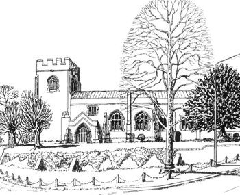 The present building dates from the twelfth century when the church became monastic property. The Norman south doorway and two-arched arcade survive while part of the masonry of the chancel and its buttresses date from the thirteenth century as does the rare stone gospel shelf. The present building dates from the twelfth century when the church became monastic property. The Norman south doorway and two-arched arcade survive while part of the masonry of the chancel and its buttresses date from the thirteenth century as does the rare stone gospel shelf.
The tower, buttresses, parapet and gargoyles date from the fifteenth century, as do the windows in the south wall of the nave.
The church was remodelled in Victorian times and we have no idea how its interior looked before that. The roof and almost all the stained glass are from the nineteenth century and the earlier decoration is lost.
The interior shows some striking features, including memorials to the families, including the Cottons, who owned the Hall and gifted the living of the church. There are also the tombs of early members of the family of Sir John Port.
The main south door and the pews in the John Port Chapel date from about 1635. The almsmen worshipped in this chapel where there are pegs, put up in 1881, for them to hang their cloaks and hats.
The plain octagonal font is believed to be fifteenth century but the pulpit is a nineteenth century addition.
The Almshouses
The money left by the second SirJohnPort in his will of 1556 built almshouses for six poor males and the number was increased to twelve in 1622. The ‘Hospital’ was run as a charity by a corporation and a resident Master. In 1681 the courtyard was built and its central archway features the arms of the Gerrard, Hastings and Stanhope families into which Sir John’s daughters had married. The East Wing was added later.
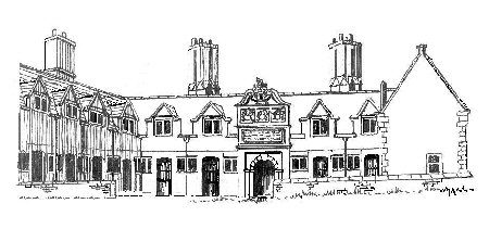 The almsmen, all men until 1867, wore livery and were disciplined in exchange for their accommodation and payment. The Master ensured sobriety and church attendance. The almsmen, all men until 1867, wore livery and were disciplined in exchange for their accommodation and payment. The Master ensured sobriety and church attendance.
The railings were erected in 1849 following some discontent and rowdy behaviour amongst the residents.
Since 1867 the almshouses have been run by a charitable trust. In 1986 the District Council and English Heritage helped to make ten modern dwellings within the existing building and the ‘Bakewell’ Gates were set in their present position. These date from 1715 and are named after their maker, a Derby ironsmith with a national reputation whose work can also be seen in Derby Cathedral. They were made as the grand entrance to Etwall Hall and display the arms of the Sleigh and Cotton families who owned the hall.
Etwall Lodge, on the edge of the village near the more southerly of the junctions of Willington Road andOaklands Road, was built in 1812 by the trustees of the Charity for the master of the almshouses and it bears the Port heraldic arms in commemoration. Modern charity law would look askance at this event, especially as the number of scholars and pensioners supported by the trust had recently been reduced.
The Old Rectory
The house dates from before 1800 and was extended over the years to become a substantial house with its own stable block and grooms’ quarters. The renovation carried out in 1999 restored the appearance from Church Hill. The original entrance was not on Church Hill but was the carriage sweep off Main Street, the gates of which are still in place opposite the Blenheim Hotel.
The Village Centre
There are references to an alehouse on the site of the Spread Eagle from Tudor times. Its present name dates from the eighteenth century and is taken from the arms of the Findern family into which one of the Port daughters married. The present building is mainly from the nineteenth century but was reworked in 1912, 1957 and 2003.
Before Willington Road was widened there was a building beside the inn that housed at various times a butcher shop, a cycle shop and a doctor’s surgery.
The present corner shops and the Post Office were built in the nineteenth century but they incorporate earlier work.
Portland Street, known as Dog Lane until the 1860s, had houses on both sides for its full length and cottages behind the present buildings on its eastern side. It led to Cat Square and the census returns show a concentration in this area of servants and manual workers. One of the village’s farriers was on Portland Street.
The Methodist Chapel
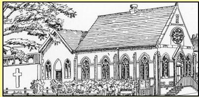 Arthur Minton of the family of porcelain makers from Stoke-on-Trent built the original chapel as a mission room in 1838 and sold it a year later to the Wesleyans for £120. In 1884 the ‘new’ chapel was built facing Willington Road. This was given a Scandinavian style interior in 1960 and in 1968 a new school room was added. The original chapel now lies at the centre of the extended building. Arthur Minton of the family of porcelain makers from Stoke-on-Trent built the original chapel as a mission room in 1838 and sold it a year later to the Wesleyans for £120. In 1884 the ‘new’ chapel was built facing Willington Road. This was given a Scandinavian style interior in 1960 and in 1968 a new school room was added. The original chapel now lies at the centre of the extended building.
Close to the chapel is a row of nineteenth century cottages.
The Old Post Office or Dutch House
The house was built at right angles to the road and later reoriented. The front adopted is early nineteenth century and follows an earlier fashion established by the use of wooden canal bridge formers in house structures. This gives the house its ‘Dutch’ style though there is no evidence that bridge timbers were actually used in its construction.
In the period up to 1965 the house served as the Post Office and telephone exchange. It had two front entrances, one domestic and one for the business. The building had a bake-house in 1849.
The Hawk and Buckle
This is a late eighteenth century building probably owing much to the Derby-Uttoxeter turnpike and influenced in its construction by the window tax that was not fully repealed until 1851. The building was owned by the Cotton family of Etwall Hall, and their arms provide its present name and sign.
The Ivies
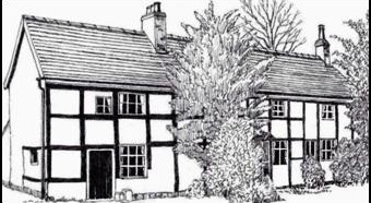 The Ivies is a two-storied timber-frame house whose internal roof construction suggests that it may date from around 1425; this could be the village’s oldest secular building. The house incorporates a beam labelled 1585 and another of 1669 marking stages in its development. The Ivies is a two-storied timber-frame house whose internal roof construction suggests that it may date from around 1425; this could be the village’s oldest secular building. The house incorporates a beam labelled 1585 and another of 1669 marking stages in its development.
This building was designed as a single house but was at one time three dwellings and is now two.
The Blenheim Hotel
The name derives from Blenheim Farm, a name likely to have been adopted close to the battle date of 1704. This was the last working farm in the village centre.
The Farm was originally at right-angles to the road and the present front was added in the 1840s. The bar and restaurant are in what was once a separate building, ‘Etwall House’.
Lawn House
Lawn House dates from 1790 but seems to be an adaptation of an earlier structure; it has a modern side extension and may have been part of the complex based round Etwall Lawns.
The Parish Room
Opposite Lawn House, the old Parochial Reading Room, or Parish Room, is part of a modern house. It is a Victorian building, paid for by the Cotton family, and opened as a coffee and reading room on winter evenings.
A village hall was opened behind The Parish Room in 1950 and served until 1991, when the Frank Wickham Hall was opened
Lawn Cottage
This was built at right angles to the road. The cottage dates from the late 1600s but is on the site of an earlier building and may incorporate part of it. Probably completely timber-framed when built, it has been extensively modified and now has brick in-fill or facing for the framing. The building had a bake-house and would have been of great local importance before the mass-produced iron range put an oven into every home..
Etwall Lawn, The Old Red House and The Limes
These houses originate from the early seventeenth century. They are joined structurally and were probably once a single residence. The Old Red House and Etwall Lawn were both occupied by members of the Harpur Crewe family of Calke Abbey during the nineteenth century.
Unfortunately, nothing survives of the Tudor-Stuart exteriors. The Old Red House has an attractive Queen Anne façade and The Limes was re-worked between 1760 and 1766 in the Georgian style.
Etwall Lawn was completely remodelled in the nineteenth century and now looks Victorian. The evidence of its earlier existence is entirely internal.
The Mount was originally a farm and Wychwood was the house of the village vet’ around 1900. They were at the top of ‘Blacksmith Hill’, named after the smithy beside Walnut Cottage, which is also a late Victorian structure.
There are rows of nineteenth century cottages, now modernised, on Main Street itself and in jitties off to the East.
Etwall Hall - John Port School
Etwall Hall was built by the second Sir John Port. It was rebuilt by Sir Samuel Sleigh, a Derby lawyer originally from the village of Ash and lord of the manor from 1646 to 1679. The stone used came from Tutbury Castle. The hall passed by marriage to the Cotton family from Shropshire, who rebuilt it again between 1712 and 1725 and owned it almost until its demolition.
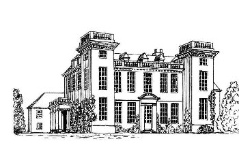 This Georgian version was much admired. It was occupied by the military during World War II but emerged from this in disrepair and was demolished to make way for the John Port School in the 1950s. This Georgian version was much admired. It was occupied by the military during World War II but emerged from this in disrepair and was demolished to make way for the John Port School in the 1950s.
The hall itself stood where the western end of the School main block now stands and the entrance lodges and gates were on the site of the present bus shelter, directly opposite Willington Road. The wall surrounding the hall ran in an arc around the village green to the road up to the cemetery and in the other direction roughly where the cycle track markers are now placed.
For about three hundred years to the late nineteenth century Etwall Hall was by far the biggest employer in the village.
The Primary School and Egginton Road
Etwall Primary School was opened in 1870 following a special Act of Parliament in 1867 promoted by the John Port Charity. The school and headmaster’s house, now occupied by the caretaker, were built on land belonging to the Charity and financed jointly by the Charity and a Government grant. By 1874 it was educating infants, girls and boys up to the age of 14 for fees of not more than nine pence a week. Fees were abolished in 1891 and the school was transferred to the new Derbyshire Local Education Authority in 1904. It took pupils from Ash, Bearwardcote, Burnaston and Egginton as well as Etwall.
On the site of the car park beside the school were several small cottages, demolished in the 1950s and near the Library site a further group of cottages and a small workhouse. Behind the school was the windmill remembered in the modern road name and featured on the Ordnance Survey maps into the twentieth century.
Towards Egginton on the east side early cottages occupy narrow plots parallel to the road. The steep bank above them may reflect excavation for marl to put on the land or brick making. It was a more general refuse dump.
The junction of Egginton Road and Chestnut Grove marks the site of a clay pit and brickworks operating in the later nineteenth century making ‘Etwell’ bricks.
Nearby, Blakely Cottage was the owner’s residence. Intriguingly, Kiln Croft in the village centre is named after Kiln Croft field which is shown on maps that precede the establishment of the brickworks and is quite inappropriately placed to be part of the Egginton Road enterprise. Quite what the name signifies is unclear but it may well be to do with lime baking or even brewing.
Further towards Egginton on the east side of the road a group of large brick houses was built in the 1880s for that new social group, the comfortably off railway commuter.
|
